.jpg)

.jpg)
.jpg)
 Secret spot
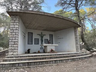
Altar of ses Roques Altes
A memorial in the woods on Sa Talaia to the 104 victims of the Iberia Flight 602 crash on 7 January 1972.


Photo credits
Secret spot · Sant Josep de sa Talaia
At 475 metres, the highest point on Ibiza, near Sant Josep. Drive to the summit or walk up from the village; on a clear day you can see Formentera.
Sa Talaia, also called Sa Talaiassa, is Ibiza’s highest mountain at 475 metres. It rises in the south-west of the island, in the municipality of Sant Josep de sa Talaia. ‘Talaia’ is Catalan for watchtower.
The summit is fairly flat. It’s home to television and telecommunications masts and a geodetic survey point. On a slightly lower peak, at around 460 metres, there’s a lookout hut used to watch for forest fires.
On a clear day you can see across much of the island, including the bay of Sant Antoni de Portmany, ses Salines and the island of Formentera. To the west lie Es Vedrà and the illots de Ponent, which are part of a nature reserve. According to the municipality, on very clear days you can even make out the coast of mainland Spain.
Look north from the masts and you’ll also see the mountain of Cap Nonó and the coastal villages of Cala de Bou and Port des Torrent. To the south lie the bay of Porroig, Cala Jondal and Platja d’en Bossa.
From the masts, walk back to the road and take the narrow path that climbs to the right up a small hill. From there you look out over the west coast of Sant Josep, including Cala Bassa and Cala Comte. Around sunset, the sun sinks into the sea on this side.
On 7 January 1972, Iberia Flight 602, a Caravelle flying from Valencia to Ibiza, struck the mountain while approaching the airport in poor visibility. All 104 people on board were killed: 98 passengers and 6 crew. At the crash site, near Ses Roques Altes, there’s a chapel with an altar bearing the names of the victims. Please be respectful when you’re there.
You can drive all the way to the summit. According to the Sant Josep municipality, the road is suitable for any type of car. Leave the village of Sant Josep in the direction of Sant Antoni and take the turning for Cala Vedella. Along that road, the route to the summit is signposted on the left. Park so that the road and access to the installations stay clear.
Prefer to walk? By the church in Sant Josep, a wooden post marks the walking route to Sa Talaia. The path starts out narrow and steep. The climb is about 2.4 km long and fairly tough; allow around 1 hour 15 minutes to reach the top.
This text was written with AI assistance and has not yet been reviewed by our editors. Editorial policy
These details come from open data sources and have not been checked by IBIZAMAP yet. Check them before you go.
Secret spotA memorial in the woods on Sa Talaia to the 104 victims of the Iberia Flight 602 crash on 7 January 1972.
 Secret spot
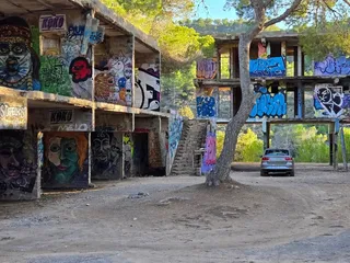
The ruins of a 1970s open-air club in the hills near the village of Sant Josep, now covered in graffiti. A derelict site with no facilities.
1.5 km away
Surprising tapas, cozy atmosphere and a welcome that feels like home.
1.6 km away
Excellent tapas and Basque dishes with attentive service and quality wines.
1.6 km away
Creative dishes, friendly service and lively atmosphere make this a southern favorite.
1.6 km away
Authentic wood-fired pizzas and burrata in a friendly setting at a fair price.